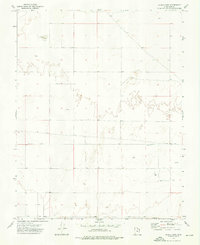
1972 Map of Clark Farm
USGS Topo · Published 1976About this map
Mud Lake and a scattered network of water sources define this arid landscape in Iron County during the early 1970s. The map illustrates a region where life and livelihood depend on managed water access, marked by the presence of numerous Well and Wells sites. The local infrastructure is anchored by the Clark Farm, representing the agricultural footprint of the era. Grounded by the straight path of Antelope Road, the terrain also shows signs of local resource extraction at a Gravel Pit. The map provides a clear record of land divisions between Range 15 West and Range 16 West, capturing the transition from the open desert floor to the localized developments of rural Utah.
Find a feature on this map
8 named features on this map. Tap any name to fly to it.
Don’t see what you’re looking for? This feature index may not catch every label — zoom into the map to look around manually.
Map Details
Editions of this 1972 Clark Farm Map
This is the sole edition of this map. No revisions or reprints were ever made.
Other maps of this area

1885 · St. George
USGS Topo · 1:250,000

1891 · St. George
USGS Topo · 1:250,000

1950 · Antelope Peak
USGS Topo · 1:24,000

1950 · Iron Mountain
USGS Topo · 1:62,500

1950 · Silver Peak
USGS Topo · 1:24,000

1951 · Silver Peak
USGS Topo · 1:24,000

1951 · Avon NW
USGS Topo · 1:24,000

1953 · Cedar City
USGS Topo · 1:250,000

1958 · Cedar City
USGS Topo · 1:250,000

1962 · Cedar City
USGS Topo · 1:250,000