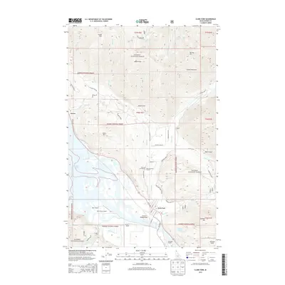
2013 Map of Clark Fork
USGS Topo · Published 2013About this map
Clark Fork sits at the northern edge of the river that shares its name, positioned where the waterway begins its transition into Lake Pend Oreille. This 2013 survey illustrates the community's relationship with the water and the surrounding Kanisku National Forest, highlighting essential local infrastructure such as the Clark Fork Fish Hatchery and the Idaho State Fish Hatchery. The landscape is defined by the sharp rise of the Cabinet Mountains to the north, where peaks like Cougar Peak and Bee Top Mtn loom over the river valley. The map documents several small airstrips including CX Ranch Airport and Delta Shores Airport, reflecting the region's reliance on private aviation for access. Toward the south, Derr Island and Antelope Lake mark the complex delta and wetlands where Lightning Creek and other tributaries meet the main river channel, creating a rich riparian environment south of the main settlement.
Find a feature on this map
59 named features on this map. Tap any name to fly to it.
Don’t see what you’re looking for? This feature index may not catch every label — zoom into the map to look around manually.
Map Details
Editions of this 2013 Clark Fork Map
This is the sole edition of this map. No revisions or reprints were ever made.
Other maps of this area

1911 · Priest Lake
USGS Topo · 1:250,000

1913 · Priest Lake
USGS Topo · 1:250,000

1949 · Packsaddle Mtn
USGS Topo · 1:62,500

1951 · Packsaddle Mtn
USGS Topo · 1:62,500

1951 · Clark Fork
USGS Topo · 1:62,500

1951 · Mt Pend Oreille
USGS Topo · 1:62,500

1951 · Elmira
USGS Topo · 1:62,500

1958 · Sandpoint
USGS Topo · 1:250,000

1963 · Sandpoint
USGS Topo · 1:250,000
1984 · Sandpoint
USGS Topo · 1:100,000