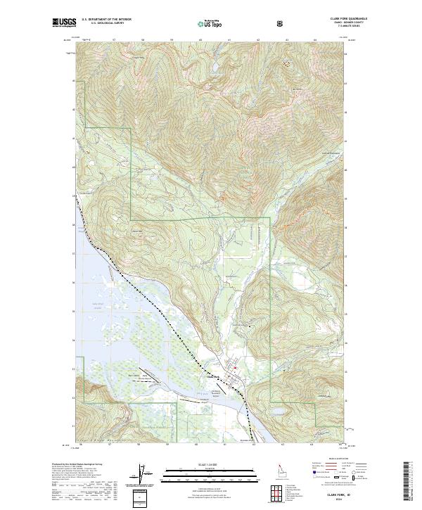
2024 Map of Clark Fork
USGS Topo · Published 2024About this map
Clark Fork sits at the confluence where its namesake river meets the eastern reaches of Lake Pend Oreille, a landscape defined by the expansive wetlands of Denton Slough and the Derr Island delta. This 2024 survey captures the settlement's layout along Main St and 4th Ave, serving as a gateway to the steep elevations of the Cabinet Mountains and Coeur d'Alene Mountains. The map reveals a high concentration of private aviation infrastructure, including CX-Ranch Airport and the Delta Shores Airport, reflecting the region's reliance on small-craft transport amidst the peaks. Heavy drainage from Lightning Creek and Mosquito Creek feeds the valley floor, while the presence of Hope Mine Rd and Clark Fork Cemetery offers touchpoints for local historians. Within the Kaniksu National Forest, the terrain rises sharply to Bee Top Mtn and Cougar Peak, crisscrossed by forestry routes like Beetop-Roundtop Trl and Lightning Creek Rd.
Find a feature on this map
88 named features on this map. Tap any name to fly to it.
Don’t see what you’re looking for? This feature index may not catch every label — zoom into the map to look around manually.
Map Details
Editions of this 2024 Clark Fork Map
This is the sole edition of this map. No revisions or reprints were ever made.
Other maps of this area

1911 · Priest Lake
USGS Topo · 1:250,000

1913 · Priest Lake
USGS Topo · 1:250,000

1949 · Packsaddle Mtn
USGS Topo · 1:62,500

1951 · Packsaddle Mtn
USGS Topo · 1:62,500

1951 · Clark Fork
USGS Topo · 1:62,500

1951 · Mt Pend Oreille
USGS Topo · 1:62,500

1951 · Elmira
USGS Topo · 1:62,500

1958 · Sandpoint
USGS Topo · 1:250,000

1963 · Sandpoint
USGS Topo · 1:250,000
1984 · Sandpoint
USGS Topo · 1:100,000