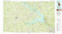
1980 Map of Clark Hill Lake
USGS Topo · Published 1981About this map
Clark Hill Lake dominates this 1980 survey, illustrating the transformative impact of the damming of the Savannah River on the border of Georgia and South Carolina. The massive reservoir defines the landscape, creating a complex shoreline that surrounds several protected areas, including the Clark Hill Wildlife Management Area and the Hickory Knob State Park. In the surrounding Georgia uplands, the town of Washington serves as a central hub, where the Georgia Railroad and local highways converge.
Find a feature on this map
126 named features on this map. Tap any name to fly to it.
Don’t see what you’re looking for? This feature index may not catch every label — zoom into the map to look around manually.
Map Details
Editions of this 1980 Clark Hill Lake Map
This is the sole edition of this map. No revisions or reprints were ever made.
Other maps of this area

1891 · Carnesville
USGS Topo · 1:125,000

1892 · Mc Cormick
USGS Topo · 1:125,000

1892 · Abbeville
USGS Topo · 1:125,000

1893 · Elberton
USGS Topo · 1:125,000

1906 · Crawfordville
USGS Topo · 1:125,000

1908 · Kirksey
USGS Topo · 1:24,000

1912 · Mc Cormick
USGS Topo · 1:125,000

1920 · Clarks Hill
USGS Topo · 1:48,000

1921 · Augusta
USGS Topo · 1:62,500

1921 · Clarks Hill
USGS Topo · 1:62,500