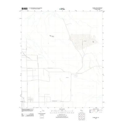
2012 Map of Clark Lake
USGS Topo · Published 2012About this map
Clark Lake dominates the eastern basin of this arid landscape, situated within the wider Clark Valley. To the west, the steep elevations of Coyote Mountain and Coyote Peak overlook the seasonal drainage of Coyote Cr. This 2012 survey illustrates the sparse human footprint in the region, centered around the Borrego Valley Airport and the residential infrastructure of Christmas Circle at the southern edge. The map provides a detailed look at the desert's primitive road and trail network, including the Santa Caterina Trl and De Anza Trl. Notable private holdings like Oliver Ranch are documented, showing how settlement has adapted to the water-scarce environment north of Borrego Springs. The terrain is defined by a grid of local roads such as Borrego Valley Rd and Henderson Canyon Rd, which terminate abruptly at the base of the mountains.
Find a feature on this map
23 named features on this map. Tap any name to fly to it.
Don’t see what you’re looking for? This feature index may not catch every label — zoom into the map to look around manually.
Map Details
Editions of this 2012 Clark Lake Map
This is the sole edition of this map. No revisions or reprints were ever made.
Other maps of this area

1904 · Indio
USGS Topo · 1:125,000

1931 · Vallecito
USGS Topo · 1:125,000

1939 · Borrego
USGS Topo · 1:62,500

1941 · Clark Lake
USGS Topo · 1:62,500

1942 · Barrel Spring
USGS Topo · 1:62,500

1942 · Agua Dulce
USGS Topo · 1:62,500

1942 · Clark Lake
USGS Topo · 1:62,500

1942 · Borego
USGS Topo · 1:62,500

1943 · Vallecito
USGS Topo · 1:125,000

1944 · Agua Dulce
USGS Topo · 1:62,500