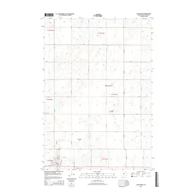
2015 Map of Clark North
USGS Topo · Published 2015About this map
Hillcrest Colony and the northern edge of Clark anchor this portion of the eastern South Dakota plains, situated upon the glacial upland known as the Coteau des Prairies. The map reveals a landscape defined by a precise section-line grid, where agricultural life is punctuated by essential community sites like Pioneer Cem, Rose Hill Cem, and Saint Boniface Cem. Transportation and infrastructure are central to the area's layout, with the Clark County Airport positioned north of the city and an industrial corridor developing along Industrial Dr and 1st Ave W. The terrain is dotted with numerous small prairie potholes and wetlands typical of the Coteau, influencing the path of rural roads like CR-28 and CR-29 as they navigate the natural hydrology of the region.
Find a feature on this map
30 named features on this map. Tap any name to fly to it.
Don’t see what you’re looking for? This feature index may not catch every label — zoom into the map to look around manually.
Map Details
Editions of this 2015 Clark North Map
This is the sole edition of this map. No revisions or reprints were ever made.
Other maps of this area

1953 · Milbank
USGS Topo · 1:250,000

1953 · Watertown
USGS Topo · 1:250,000

1958 · Milbank
USGS Topo · 1:250,000

1958 · Watertown
USGS Topo · 1:250,000

1973 · Bradley
USGS Topo · 1:24,000

1973 · Heggs Lake
USGS Topo · 1:24,000
1973 · Crocker
USGS Topo · 1:24,000
1973 · Baileys Lake
USGS Topo · 1:24,000

1973 · Garden City
USGS Topo · 1:24,000

1973 · Clark South
USGS Topo · 1:24,000