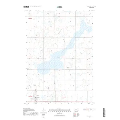
2017 Map of Clark North
USGS Topo · Published 2017About this map
The settlement of Clark anchors the southern portion of this South Dakota landscape, positioned at the edge of the Coteau des Prairies upland. The area is defined by its glacial heritage, where the rolling terrain holds significant water features like Dry Lake Number One and Caseys Slough. For those tracing local heritage, the map identifies several key burial sites including Pioneer Cem, Rose Hill Cem, and Saint Boniface Cem, which sit near the intersection of section lines and early township boundaries. The landscape is organized by a strict grid of county roads, including Co RD 6 and Co RD 52, reflecting the systematic agricultural development of the region. Transportation and infrastructure are further marked by the Clark County Airport, serving as a modern landmark amidst the sprawling prairie and marshland that characterizes this part of Clark County.
Find a feature on this map
25 named features on this map. Tap any name to fly to it.
Don’t see what you’re looking for? This feature index may not catch every label — zoom into the map to look around manually.
Map Details
Editions of this 2017 Clark North Map
This is the sole edition of this map. No revisions or reprints were ever made.
Other maps of this area

1953 · Milbank
USGS Topo · 1:250,000

1953 · Watertown
USGS Topo · 1:250,000

1958 · Milbank
USGS Topo · 1:250,000

1958 · Watertown
USGS Topo · 1:250,000

1973 · Bradley
USGS Topo · 1:24,000

1973 · Heggs Lake
USGS Topo · 1:24,000
1973 · Crocker
USGS Topo · 1:24,000
1973 · Baileys Lake
USGS Topo · 1:24,000

1973 · Garden City
USGS Topo · 1:24,000

1973 · Clark South
USGS Topo · 1:24,000