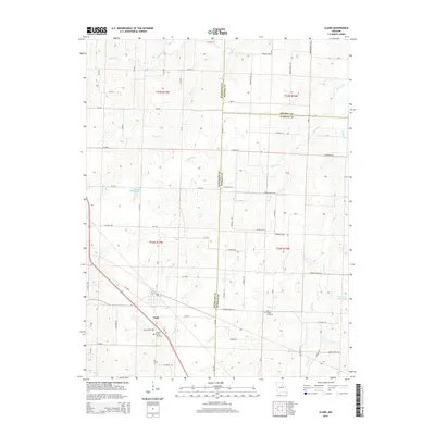
2014 Map of Clark
USGS Topo · Published 2014About this map
The town of Clark anchors this survey at the intersection of Randolph, Monroe, and Audrain counties, illustrating a landscape defined by its rolling creek drainages and agricultural grid. The terrain is deeply etched by a network of waterways including Saling Cr, Big Cr, and the Lick Fork, which flow through the dissected uplands of northern Missouri. This 2014 mapping reveals how early transportation routes have evolved into a modern system of county roads and state highways like Mo-Y and Mo-NN, while maintaining the historical placement of local landmarks. Genealogists and local historians can locate several important sites such as the Chapel Grove Cemetery and Mount Pisgah Cemetery, both situated amidst the farmland. The map also documents contemporary water features like Cedarlane Farms Lake and Milnes Lake, reflecting the region's managed rural landscape.
Find a feature on this map
77 named features on this map. Tap any name to fly to it.
Don’t see what you’re looking for? This feature index may not catch every label — zoom into the map to look around manually.
Map Details
Editions of this 2014 Clark Map
This is the sole edition of this map. No revisions or reprints were ever made.
Other maps of this area

1890 · Moberly
USGS Topo · 1:125,000

1917 · Sturgeon
USGS Topo · 1:62,500

1945 · Centralia
USGS Topo · 1:62,500

1952 · Middle Grove
USGS Topo · 1:24,000

1953 · Moberly
USGS Topo · 1:250,000

1953 · Renick
USGS Topo · 1:24,000

1953 · Clark
USGS Topo · 1:24,000
1953 · Moberly
USGS Topo · 1:24,000

1954 · Moberly
USGS Topo · 1:250,000

1957 · Moberly
USGS Topo · 1:250,000