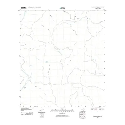
2010 Map of Clark Waterhole
USGS Topo · Published 2010About this map
Devils River and its ephemeral counterpart, Dry Devils River, dictate the drainage patterns across this arid portion of Val Verde County. The landscape is deeply incised by complex canyon systems, including Gold Mine Canyon, Sheep Camp Canyon, and Burnt Cedar Canyon. These features illustrate the rugged limestone topography characteristic of the Edwards Plateau. Historical human presence is marked by the Newman Cemetery and a sparse network of ranch roads such as Hussie Meiers Rd and Dolan Creek Rd. Water management is vital in this environment, evidenced by named reliable sources like Carlos Camp Spring, Glenn Spring, and the namesake Clark Waterhole. The map reveals how early 21st-century ranching life centers on these intermittent streams and vital springs tucked within deep basins like Toliver Basin Canyon.
Find a feature on this map
24 named features on this map. Tap any name to fly to it.
Don’t see what you’re looking for? This feature index may not catch every label — zoom into the map to look around manually.
Map Details
Editions of this 2010 Clark Waterhole Map
This is the sole edition of this map. No revisions or reprints were ever made.
Other maps of this area

1941 · Feely
USGS Topo · 1:62,500

1944 · Dry Devil
USGS Topo · 1:62,500

1944 · Devils Lake
USGS Topo · 1:62,500

1944 · Baker Crossing
USGS Topo · 1:62,500

1958 · Del Rio
USGS Topo · 1:250,000

1964 · Del Rio
USGS Topo · 1:250,000

1972 · Miers Ranch
USGS Topo · 1:24,000
1972 · Satan Canyon
USGS Topo · 1:24,000
1972 · Gillis Ranch
USGS Topo · 1:24,000
1978 · Open Hollow
USGS Topo · 1:24,000