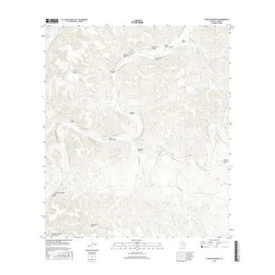
2016 Map of Clark Waterhole
USGS Topo · Published 2016About this map
The Dry Devils River drainage defines this arid Val Verde County landscape, carving a network of canyons and draws across the plateau. Ranching and remote operations are the primary human footprint, evidenced by the Rio Vista Ranch Airport and Morning Star Ranch Airport providing critical aerial access to this isolated West Texas terrain. Local history and genealogy are anchored by the Newman Cem near Manuel Canyon, while the name Gold Mine Canyon hints at early prospecting efforts in the region.
Find a feature on this map
26 named features on this map. Tap any name to fly to it.
Don’t see what you’re looking for? This feature index may not catch every label — zoom into the map to look around manually.
Map Details
Editions of this 2016 Clark Waterhole Map
This is the sole edition of this map. No revisions or reprints were ever made.
Other maps of this area

1941 · Feely
USGS Topo · 1:62,500

1944 · Dry Devil
USGS Topo · 1:62,500

1944 · Devils Lake
USGS Topo · 1:62,500

1944 · Baker Crossing
USGS Topo · 1:62,500

1958 · Del Rio
USGS Topo · 1:250,000

1964 · Del Rio
USGS Topo · 1:250,000

1972 · Miers Ranch
USGS Topo · 1:24,000
1972 · Satan Canyon
USGS Topo · 1:24,000
1972 · Gillis Ranch
USGS Topo · 1:24,000
1978 · Open Hollow
USGS Topo · 1:24,000