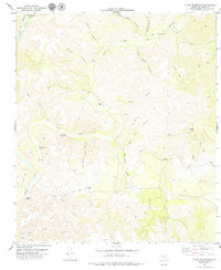
1979 Map of Clark Waterhole
USGS Topo · Published 1979About this map
The Devils River corridor in Val Verde County is defined by its canyon systems and critical water sources in an arid landscape. In this late 1970s survey, the area is characterized by remote settlements and specific named water points like Clark Waterhole, Blocker Waterhole, and Gravel Waterhole. Human presence is marked by scattered livestock and ranching infrastructure, including the isolated Carlos Camp and a small Newman Cem located near Gravel Waterhole.
Find a feature on this map
34 named features on this map. Tap any name to fly to it.
Don’t see what you’re looking for? This feature index may not catch every label — zoom into the map to look around manually.
Map Details
Editions of this 1979 Clark Waterhole Map
This is the sole edition of this map. No revisions or reprints were ever made.
Other maps of this area

1941 · Feely
USGS Topo · 1:62,500

1944 · Dry Devil
USGS Topo · 1:62,500

1944 · Devils Lake
USGS Topo · 1:62,500

1944 · Baker Crossing
USGS Topo · 1:62,500

1958 · Del Rio
USGS Topo · 1:250,000

1964 · Del Rio
USGS Topo · 1:250,000

1972 · Miers Ranch
USGS Topo · 1:24,000
1972 · Satan Canyon
USGS Topo · 1:24,000
1972 · Gillis Ranch
USGS Topo · 1:24,000
1978 · Open Hollow
USGS Topo · 1:24,000