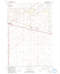
1993 Map of Clarke
USGS Topo · Published 1993About this map
Naval Weapons Systems Training Facility lands dominate this corner of Morrow County, where military operations and desert conservation meet. In this early 1990s landscape, the Umatilla National Wildlife Refuge borders the high desert terrain, marked by scattered water sources like Coyote Spring and Lower Sand Spring. The settlement of Clarke and the nearby Boardman Junction serve as points of orientation amidst a network of rural routes including Paterson Ferry Road and Homestead Road. Infrastructure for agriculture and defense is prominent throughout, from the West Extension Irrigation Canal to a dedicated Rifle Range and Landing Strip. This geography illustrates the transition from the river-adjacent refuge lands to the expansive high-desert installations of the Umatilla Activity Depot.
Find a feature on this map
20 named features on this map. Tap any name to fly to it.
Don’t see what you’re looking for? This feature index may not catch every label — zoom into the map to look around manually.
Map Details
Editions of this 1993 Clarke Map
This is the sole edition of this map. No revisions or reprints were ever made.
Other maps of this area

1906 · Blalock Island
USGS Topo · 1:125,000

1908 · Blalock Island
USGS Topo · 1:125,000

1908 · Umatilla
USGS Topo · 1:125,000

1953 · Pendleton
USGS Topo · 1:250,000

1956 · Pendleton
USGS Topo · 1:250,000

1962 · Blalock Island
USGS Topo · 1:24,000

1962 · Ordnance
USGS Topo · 1:24,000

1962 · Paterson
USGS Topo · 1:24,000

1962 · Boardman
USGS Topo · 1:24,000

1962 · Clarke
USGS Topo · 1:24,000