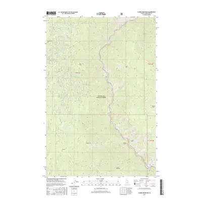
2017 Map of Clarke Mountain
USGS Topo · Published 2017About this map
The North Fork Clearwater River carves a deep valley through the high country of the Clearwater National Forest, serving as the primary geographic corridor for this portion of Idaho. This landscape is defined by its dramatic verticality, with prominent landmarks such as Clarke Mountain, Elk Mtn, and Deadhorse Mtn overlooking a network of tributary drainages including Washington Cr and Lolo Cr. The river's path is shadowed by Co RD 247, the main thoroughfare that provides access through the steep terrain to isolated points like Morgans Gulch and Cave Point. The map captures the interplay between this major waterway and its rugged canyon walls, where features like Castle Rock and Chateau Rock stand as natural monuments within the forest. Geologists and local historians can trace the intricate drainages from Deadhorse Cr in the north to Knute Cr in the south, reflecting the traditional timber and resource management areas of the region.
Find a feature on this map
37 named features on this map. Tap any name to fly to it.
Don’t see what you’re looking for? This feature index may not catch every label — zoom into the map to look around manually.
Map Details
Editions of this 2017 Clarke Mountain Map
This is the sole edition of this map. No revisions or reprints were ever made.
Other maps of this area

1911 · Lolo
USGS Topo · 1:250,000

1913 · Lolo
USGS Topo · 1:250,000

1923 · Washington Creek
USGS Topo · 1:125,000

1956 · Hamilton
USGS Topo · 1:250,000

1959 · Hamilton
USGS Topo · 1:250,000

1960 · Hamilton
USGS Topo · 1:250,000

1963 · Sheep Mtn
USGS Topo · 1:24,000
1963 · The Nub
USGS Topo · 1:24,000

1963 · Clarke Mtn
USGS Topo · 1:24,000

1964 · Hamilton
USGS Topo · 1:250,000