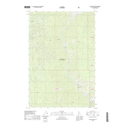
2020 Map of Clarke Mountain
USGS Topo · Published 2020About this map
The North Fork Clearwater River carves a deep path through this section of the Clearwater National Forest, serving as the primary drainage for a network of high ridges and deep gulches. In this steep Idaho landscape, the river is flanked by dramatic geological formations like Castle Rock and Chateau Rock, while high elevations are marked by Clarke Mtn and Elk Mtn. The drainage patterns are clearly defined by numerous tributaries such as Orogrande Cr and Deadhorse Cr. Access into these high reaches is limited to forest routes like Co Rd 247 and Protection Rd, which traverse the terrain between peaks such as Deadhorse Mtn and Shin Point. The map provides a detailed view of the watershed's topography as it existed in 2020, illustrating the relationship between the central river corridor and the surrounding mountain summits.
Find a feature on this map
39 named features on this map. Tap any name to fly to it.
Don’t see what you’re looking for? This feature index may not catch every label — zoom into the map to look around manually.
Map Details
Editions of this 2020 Clarke Mountain Map
This is the sole edition of this map. No revisions or reprints were ever made.
Other maps of this area

1911 · Lolo
USGS Topo · 1:250,000

1913 · Lolo
USGS Topo · 1:250,000

1923 · Washington Creek
USGS Topo · 1:125,000

1956 · Hamilton
USGS Topo · 1:250,000

1959 · Hamilton
USGS Topo · 1:250,000

1960 · Hamilton
USGS Topo · 1:250,000

1963 · Sheep Mtn
USGS Topo · 1:24,000
1963 · The Nub
USGS Topo · 1:24,000

1963 · Clarke Mtn
USGS Topo · 1:24,000

1964 · Hamilton
USGS Topo · 1:250,000