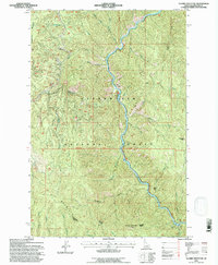
1994 Map of Clarke Mountain
USGS Topo · Published 1997About this map
The North Fork Clearwater River winds deeply through the heart of the Clearwater National Forest in this mid-1990s topographical study. This section of the Idaho backcountry is defined by significant elevations, including Deadhorse Mountain and Elk Mountain, with the prominent summit of Clarke Mountain overlooking the southern reach. The river's path is tracked by technical infrastructure like a Gaging Sta and a Water Tank, while a Ranger Station denotes the administrative presence in this remote drainage basin.
Find a feature on this map
25 named features on this map. Tap any name to fly to it.
Don’t see what you’re looking for? This feature index may not catch every label — zoom into the map to look around manually.
Map Details
Editions of this 1994 Clarke Mountain Map
This is the sole edition of this map. No revisions or reprints were ever made.
Other maps of this area

1911 · Lolo
USGS Topo · 1:250,000

1913 · Lolo
USGS Topo · 1:250,000

1923 · Washington Creek
USGS Topo · 1:125,000

1956 · Hamilton
USGS Topo · 1:250,000

1959 · Hamilton
USGS Topo · 1:250,000

1960 · Hamilton
USGS Topo · 1:250,000

1963 · Sheep Mtn
USGS Topo · 1:24,000
1963 · The Nub
USGS Topo · 1:24,000

1963 · Clarke Mtn
USGS Topo · 1:24,000

1964 · Hamilton
USGS Topo · 1:250,000