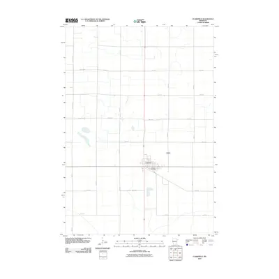
2010 Map of Clarkfield
USGS Topo · Published 2010About this map
Clarkfield serves as the central hub for this portion of Yellow Medicine County, defined by its traditional grid and essential civic anchors like the Clarkfield Post Office. The landscape is shaped by an extensive network of rural corridors, including County Hwy-35 and County Hwy-2, which facilitate the agricultural transit fundamental to the region's economy. The topography is notably marked by small prairie potholes and water bodies scattered across the northwest and southeast, reflecting the glacial heritage of the Minnesota prairie. To the northeast of the town center, the Clarkfield Cemetery provides a primary point of interest for genealogists and local historians tracking the area's family lineages. This 2010 survey reflects the enduring structure of a Minnesota farm community, where the intersection of roads like 310th Ave and 410th St maintains the township and range system that has organized this land for generations.
Find a feature on this map
19 named features on this map. Tap any name to fly to it.
Don’t see what you’re looking for? This feature index may not catch every label — zoom into the map to look around manually.
Map Details
Editions of this 2010 Clarkfield Map
This is the sole edition of this map. No revisions or reprints were ever made.
Other maps of this area

1953 · New Ulm
USGS Topo · 1:250,000

1957 · New Ulm
USGS Topo · 1:250,000

1958 · New Ulm
USGS Topo · 1:250,000

1962 · Wood Lake NW
USGS Topo · 1:24,000

1965 · Montevideo
USGS Topo · 1:24,000

1965 · Clarkfield
USGS Topo · 1:24,000
1965 · Clarkfield NE
USGS Topo · 1:24,000
1965 · Tenmile Lake
USGS Topo · 1:24,000

1965 · Hazel Run
USGS Topo · 1:24,000

1965 · Boyd
USGS Topo · 1:24,000