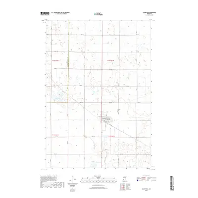
2019 Map of Clarkfield
USGS Topo · Published 2019About this map
Clarkfield serves as the primary hub of this agricultural landscape, situated at the intersection of a precise grid of rural routes. The town's layout is defined by numbered avenues including 10th Ave and 8th Ave, extending toward the Clarkfield Cem on the northeastern edge of the settlement. The surrounding terrain is a mosaic of cultivated fields and wetlands, most notably the seasonal waters of Flinks Slough. This survey captures the region as it transitioned into the late 2010s, maintaining its historical county line between Lac Qui Parle and Yellow Medicine counties. The map reflects a highly organized rural economy where large farm tracts are connected by an extensive network of roads like 400th St and 300th Ave, revealing the enduring structure of Minnesota's prairie townships.
Find a feature on this map
37 named features on this map. Tap any name to fly to it.
Don’t see what you’re looking for? This feature index may not catch every label — zoom into the map to look around manually.
Map Details
Editions of this 2019 Clarkfield Map
This is the sole edition of this map. No revisions or reprints were ever made.
Other maps of this area

1953 · New Ulm
USGS Topo · 1:250,000

1957 · New Ulm
USGS Topo · 1:250,000

1958 · New Ulm
USGS Topo · 1:250,000

1962 · Wood Lake NW
USGS Topo · 1:24,000

1965 · Montevideo
USGS Topo · 1:24,000

1965 · Clarkfield
USGS Topo · 1:24,000
1965 · Clarkfield NE
USGS Topo · 1:24,000
1965 · Tenmile Lake
USGS Topo · 1:24,000

1965 · Hazel Run
USGS Topo · 1:24,000

1965 · Boyd
USGS Topo · 1:24,000