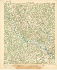
1921 Map of Clarks Hill
USGS Topo · Published 1921About this map
The Savannah River defines this 1921 landscape, serving as both a natural boundary and a hub of river activity before the era of modern reservoirs. Multiple river crossings including Gilchrist Ferry, Dents Ferry, and Middleton Ferry connect the South Carolina and Georgia banks, while the Charleston and Western Carolina railroad facilitates commerce through settlements like Modoc, Clarks Hill, and Meriwether.
Find a feature on this map
68 named features on this map. Tap any name to fly to it.
Don’t see what you’re looking for? This feature index may not catch every label — zoom into the map to look around manually.
Map Details
Editions of this 1921 Clarks Hill Map
3 editions found
Other maps of this area

1892 · Mc Cormick
USGS Topo · 1:125,000

1912 · Mc Cormick
USGS Topo · 1:125,000

1920 · Clarks Hill
USGS Topo · 1:48,000

1921 · Augusta
USGS Topo · 1:62,500

1921 · Clarks Hill
USGS Topo · 1:62,500

1921 · Appling
USGS Topo · 1:62,500

1922 · Harlem
USGS Topo · 1:62,500

1922 · Hephzibah
USGS Topo · 1:62,500

1923 · Warrenville
USGS Topo · 1:48,000

1928 · Warrenville
USGS Topo · 1:62,500