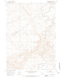
1951 Map of Clarkson Hill
USGS Topo · Published 1975About this map
Oregon Trail and Emigrant Trail paths cross the arid landscape of central Wyoming, tracing the historic route of westward expansion through Clarkson Hill. The geography is defined by the winding descent of Poison Spring Creek and Willow Creek toward the N Platte River, which cuts through the southeastern corner of the sheet. At the time of this mid-century field check, the landscape reflects a ranching and infrastructure economy, centered around the Clarkson Ranch and technical markers of the region's development like the Willow Creek Pumping Sta No 1. The intricate contouring illustrates the complex drainage patterns of Lone Tree Gulch and the broad expanse of Schrader Flats, while the irrigation network of the Casper Canal highlights human efforts to manage the high-desert environment for agricultural use in the Missouri River Basin.
Find a feature on this map
14 named features on this map. Tap any name to fly to it.
Don’t see what you’re looking for? This feature index may not catch every label — zoom into the map to look around manually.
Map Details
Editions of this 1951 Clarkson Hill Map
3 editions found
Other maps of this area

1950 · Emigrant Gap
USGS Topo · 1:24,000

1950 · Alcova SE
USGS Topo · 1:24,000

1950 · Alcova
USGS Topo · 1:24,000

1951 · Oil Mountain
USGS Topo · 1:24,000

1951 · Clarkson Hill
USGS Topo · 1:24,000

1951 · Benton Basin
USGS Topo · 1:24,000

1951 · Poison Spider
USGS Topo · 1:24,000

1951 · Bessemer Mountain
USGS Topo · 1:24,000

1951 · Benton Basin NE
USGS Topo · 1:24,000

1955 · Casper
USGS Topo · 1:250,000