
1951 Map of Benton Basin NE
USGS Topo · Published 1953About this map
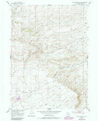
The Rattle Snake Range dominates this mid-century Wyoming landscape, showing a transition from the rugged highlands down to the basin floor. This 1951 field-checked survey documents a rugged ranching and resource corridor in Natrona County where water and infrastructure define human presence. The Oregon Trail Pipe Line cuts across the terrain, illustrating the modern industrial layer superimposed on a region historically defined by its springs and drainages. The Young Ranch stands as a focal point of settlement along the base of Ryan Hill, positioned near Willow Spring. The network of seasonal drainages, including Poison Creek, Iron Creek, and Willow Creek, highlights the importance of water management in the high plains, further evidenced by the Fish Ditch in the southwest corner. This map captures the intersection of cattle ranching and early energy transit routes on the approach to Alcova.
Find a feature on this map
15 named features on this map. Tap any name to fly to it.
Don’t see what you’re looking for? This feature index may not catch every label — zoom into the map to look around manually.
Map Details
Editions of this 1951 Benton Basin NE Map
2 editions found
Other maps of this area

1950 · Alcova
USGS Topo · 1:24,000

1951 · Pine Mountain SW
USGS Topo · 1:24,000

1951 · Oil Mountain
USGS Topo · 1:24,000

1951 · Clarkson Hill
USGS Topo · 1:24,000

1951 · Benton Basin SW
USGS Topo · 1:24,000

1951 · Benton Basin
USGS Topo · 1:24,000

1951 · Poison Spider
USGS Topo · 1:24,000

1951 · Mc Cleary Reservoir
USGS Topo · 1:24,000

1955 · Casper
USGS Topo · 1:250,000

1958 · Casper
USGS Topo · 1:250,000