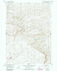
1951 Map of Benton Basin NE
USGS Topo · Published 1985About this map
The Oregon Trail cuts through this high-altitude landscape of central Wyoming, following the natural contours of the land south of Poison Creek. This mid-century survey documents the historical path of westward migration alongside modern infrastructure like the Pipe Line and Oregon Trail Road. The terrain is defined by a dense network of seasonal drainages including Iron Creek, Willow Creek, and Shell Creek, which draw toward the Benton Basin area. Human presence is concentrated at the Young Ranch, located near the base of Ryan Hill. This map illustrates the transition from traditional ranching and historic trails to mid-century industrial development, with several Windmills scattered across the northern sections to support livestock in this arid environment. The complex drainage patterns of West Fork Meadow Creek and Eagle Creek provide a clear picture of the watershed as it was managed in the early 1950s.
Find a feature on this map
15 named features on this map. Tap any name to fly to it.
Don’t see what you’re looking for? This feature index may not catch every label — zoom into the map to look around manually.
Map Details
Editions of this 1951 Benton Basin NE Map
2 editions found
Other maps of this area

1950 · Alcova
USGS Topo · 1:24,000

1951 · Pine Mountain SW
USGS Topo · 1:24,000

1951 · Oil Mountain
USGS Topo · 1:24,000

1951 · Clarkson Hill
USGS Topo · 1:24,000

1951 · Benton Basin SW
USGS Topo · 1:24,000

1951 · Benton Basin
USGS Topo · 1:24,000

1951 · Poison Spider
USGS Topo · 1:24,000

1951 · Benton Basin NE
USGS Topo · 1:24,000

1951 · Mc Cleary Reservoir
USGS Topo · 1:24,000

1955 · Casper
USGS Topo · 1:250,000