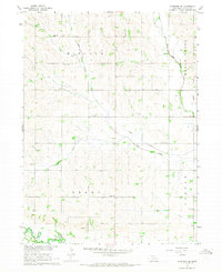
1966 Map of Clarkson SE
USGS Topo · Published 1968About this map
Agricultural life in Colfax County follows the drainage of Dry Creek and the South Fork as documented in the mid-1960s. The landscape of Midland and Grant townships is defined by a dense network of country schools and family-associated cemeteries that speak to the area's rural heritage. Notable landmarks include St Johns Cem, Cedar Hill Cem, and Praha Sch, reflecting the community nodes established by early Nebraska settlers. The Dry Creek Canal and various drainage forks, including West Fork Maple Creek, illustrate the sophisticated water management required for farming these plains. This period before widespread consolidation preserved many local sites like School No 28 and the Gravel Pit that are vital for genealogical research and mapping the evolution of local townships.
Find a feature on this map
22 named features on this map. Tap any name to fly to it.
Don’t see what you’re looking for? This feature index may not catch every label — zoom into the map to look around manually.
Map Details
Editions of this 1966 Clarkson SE Map
This is the sole edition of this map. No revisions or reprints were ever made.
Other maps of this area

1899 · Wahoo
USGS Topo · 1:125,000

1899 · David City
USGS Topo · 1:125,000

1955 · Fremont
USGS Topo · 1:250,000

1957 · Fremont
USGS Topo · 1:250,000

1958 · Fremont
USGS Topo · 1:250,000

1966 · Clarkson SW
USGS Topo · 1:24,000

1966 · Clarkson
USGS Topo · 1:24,000

1966 · Dodge SW
USGS Topo · 1:24,000
1966 · Dodge
USGS Topo · 1:24,000
1966 · Leigh
USGS Topo · 1:24,000