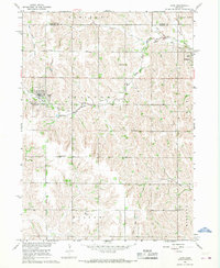
1966 Map of Leigh
USGS Topo · Published 1968About this map
The agricultural landscape along the Stanton Co Colfax Co boundary is defined by the winding paths of Maple Creek and its West Fork. Centered on the town of Leigh, this mid-century survey reveals a rural society structured around local education and faith, evidenced by numerous country schools such as Fairview Sch and School No 30. The presence of several distinct burial grounds, including Bohemian Cem, St Marys Cem, and Zion Cem, speaks to the diverse heritage of the settlers who established these communities. An old Railroad Grade cuts across the northern terrain, indicating a shift in the local transportation network as older rail lines gave way to the modern road system. The map also traces the southern limits of Ramshorn and the northern reaches of Wilson and Midland, providing a clear view of the township and range organization that governed Nebraska land use.
Find a feature on this map
24 named features on this map. Tap any name to fly to it.
Don’t see what you’re looking for? This feature index may not catch every label — zoom into the map to look around manually.
Map Details
Editions of this 1966 Leigh Map
This is the sole edition of this map. No revisions or reprints were ever made.
Other maps of this area

1955 · Fremont
USGS Topo · 1:250,000

1957 · Fremont
USGS Topo · 1:250,000

1958 · Fremont
USGS Topo · 1:250,000

1963 · Madison SE
USGS Topo · 1:24,000

1966 · Clarkson SW
USGS Topo · 1:24,000

1966 · Humphrey SE
USGS Topo · 1:24,000

1966 · Clarkson
USGS Topo · 1:24,000

1966 · Creston
USGS Topo · 1:24,000
1966 · Stanton SE
USGS Topo · 1:24,000
1966 · Stanton SW
USGS Topo · 1:24,000