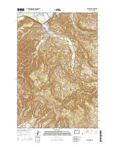
2014 Map of Clatskanie
USGS Topo · Published 2014About this map
Clatskanie serves as the focal point of this 2014 survey, positioned where the Clatskanie River winds through the Columbia River lowlands. The map details a landscape defined by the transition from river-bottom drainage projects, such as the Beaver Dredge-Cut and Erickson Dike Rd, to the timbered ridges of the Northern Oregon Coast Range. Local history is anchored by several burial grounds including Maplewood Cem, Murray Hill Cem, and Bryant Cem.
Find a feature on this map
87 named features on this map. Tap any name to fly to it.
Don’t see what you’re looking for? This feature index may not catch every label — zoom into the map to look around manually.
Map Details
Editions of this 2014 Clatskanie Map
This is the sole edition of this map. No revisions or reprints were ever made.
Other maps of this area

1919 · Mayger
USGS Topo · 1:62,500

1940 · Vernonia
USGS Topo · 1:62,500

1941 · Keasey
USGS Topo · 1:62,500

1941 · Clatskanie
USGS Topo · 1:62,500

1941 · Cathlamet
USGS Topo · 1:62,500

1943 · Vernonia
USGS Topo · 1:62,500

1943 · Keasey
USGS Topo · 1:62,500

1948 · Vancouver
USGS Topo · 1:250,000

1950 · Vancouver
USGS Topo · 1:250,000

1950 · Vancouver
USGS Topo · 1:250,000