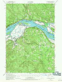
1952 Map of Clatskanie
USGS Topo · Published 1971About this map
The Columbia River corridor dominates this 1952 revision, serving as a complex maritime and industrial artery between Oregon and Washington. The river is a maze of tidewater features including Gull Island, Crims Island, and the winding Bradbury Slough. On the Oregon side, the town of Clatskanie is situated at the edge of the floodplains, while the surrounding timbered hills are home to a network of rural settlements and abandoned institutions. Evidence of early twentieth-century education is preserved in the locations of the Cedar Grove Sch (Aban'd) and Lost Creek Sch (Aban'd). The map details a landscape transitioning from the river-bottom economy of Mayger and Quincy to the upland forests marked by the Benson Lookout and small inland hamlets like Swedetown and Apiary.
Find a feature on this map
74 named features on this map. Tap any name to fly to it.
Don’t see what you’re looking for? This feature index may not catch every label — zoom into the map to look around manually.
Map Details
Editions of this 1952 Clatskanie Map
3 editions found

Other maps of this area

1919 · Mayger
USGS Topo · 1:62,500

1921 · Kalama
USGS Topo · 1:62,500

1922 · St. Helens
USGS Topo · 1:62,500

1940 · Vernonia
USGS Topo · 1:62,500

1941 · Keasey
USGS Topo · 1:62,500

1941 · St Helens
USGS Topo · 1:62,500

1941 · Olequa
USGS Topo · 1:62,500

1941 · Skamokawa
USGS Topo · 1:62,500

1941 · Clatskanie
USGS Topo · 1:62,500

1941 · Cathlamet
USGS Topo · 1:62,500