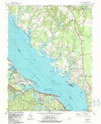
1984 Map of Clay Bank
USGS Topo · Published 1989About this map
The York River dominates this coastal landscape, shaping the development of Gloucester County and York County during the late twentieth century. Extensive military installations, including the Camp Peary Naval Res and the US Naval Weapons Station, occupy significant portions of the southern shoreline, illustrating the region's strategic importance. These modern facilities sit alongside deep-rooted Virginia history, evidenced by the Bellfield Plantation Site and numerous historic congregations such as Abingdon Ch and Providence Ch.
Find a feature on this map
69 named features on this map. Tap any name to fly to it.
Don’t see what you’re looking for? This feature index may not catch every label — zoom into the map to look around manually.
Map Details
Editions of this 1984 Clay Bank Map
3 editions found
Other maps of this area

1906 · Williamsburg
USGS Topo · 1:62,500

1907 · Yorktown
USGS Topo · 1:62,500

1907 · Hampton
USGS Topo · 1:62,500

1916 · Mathews
USGS Topo · 1:62,500

1917 · Mathews
USGS Topo · 1:62,500

1943 · Yorktown
USGS Topo · 1:62,500

1943 · Richmond
USGS Topo · 1:250,000

1944 · Yorktown
USGS Topo · 1:24,000

1944 · Harris Grove
USGS Topo · 1:24,000

1948 · Ware Neck
USGS Topo · 1:24,000