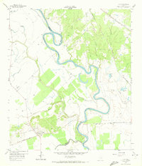
1959 Map of Clay
USGS Topo · Published 1972About this map
The Brazos River creates a serpentine border between Burleson, Washington, and Brazos Counties, defining the agricultural and industrial character of the region. The settlement of Clay serves as a local hub, situated near the confluence of several major rail lines including the Gulf Colorado and Santa Fe and the Missouri Pacific. The landscape is marked by the shifting path of the river, evidenced by the Old River channel and the pronounced Big Bend meander. Local industry is visible through multiple extraction sites like the Clay Pit and various gravel pits. For genealogists, the map preserves the locations of several burial grounds, including Botts Ferry Cem, Clay Cem, and Thomas Cem. The presence of Clay Lake and Tennessee Lake further illustrates the complex hydrology of the river bottomlands during the late 1950s.
Find a feature on this map
30 named features on this map. Tap any name to fly to it.
Don’t see what you’re looking for? This feature index may not catch every label — zoom into the map to look around manually.
Map Details
Editions of this 1959 Clay Map
3 editions found
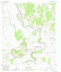
Other maps of this area

1913 · Millican
USGS Topo · 1:31,680

1914 · Gay Hill
USGS Topo · 1:62,500

1914 · Navasota
USGS Topo · 1:62,500

1954 · Austin
USGS Topo · 1:250,000

1956 · Bryan
USGS Topo · 1:62,500

1956 · Carlos
USGS Topo · 1:62,500

1958 · Washington
USGS Topo · 1:24,000

1959 · Millican
USGS Topo · 1:24,000

1959 · Gay Hill
USGS Topo · 1:24,000

1959 · Clay
USGS Topo · 1:24,000