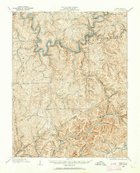
1908 Map of Clay
USGS Topo · Published 1962About this map
The Elk River winds through the heart of this central West Virginia territory, serving as the primary corridor for the Coal and Coke Ry and early 20th-century commerce. Near the river's great bends, the seat of local government at Clay Courthouse Station and the Clay PO provide a focal point for a landscape defined by deep hollows and narrow ridges. Settlement patterns follow the water, with the Buffalo Creek and Gauley RR extending northeast toward Swandale and the Chesapeake and Ohio RR cutting through the southern reaches near Dixie and Vaughan. Genealogists will find a wealth of specific locale names, including now-obscure points like Yankee Dam PO, Eldorado PO, and the Triplett School. The map captures the industrial character of the era, where timber and coal transport dictated the growth of small rail-side communities like Dundon and Elkhurst.
Find a feature on this map
121 named features on this map. Tap any name to fly to it.
Don’t see what you’re looking for? This feature index may not catch every label — zoom into the map to look around manually.
Map Details
Editions of this 1908 Clay Map
2 editions found

Other maps of this area

1889 · Nicholas
USGS Topo · 1:125,000

1891 · Nicholas
USGS Topo · 1:125,000

1893 · Sutton
USGS Topo · 1:125,000

1897 · Kanawha Falls
USGS Topo · 1:125,000

1900 · Kanawha Falls
USGS Topo · 1:125,000

1901 · Nicholas
USGS Topo · 1:125,000

1901 · Kanawha Falls
USGS Topo · 1:125,000

1906 · Otter
USGS Topo · 1:62,500

1906 · Walton
USGS Topo · 1:62,500

1907 · Otter
USGS Topo · 1:62,500