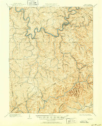
1910 Map of Clay
USGS Topo · Published 1950About this map
The Elk River winds through the heart of Clay County, serving as the primary corridor for settlement and industry at the turn of the century. This survey, conducted just after the completion of the Coke and Coke RR, documents a landscape in transition as timber and mineral extraction reshaped central West Virginia. Small post offices such as Camp Procious PO and Eldorado PO dot the riverbanks, while the administrative hub at Clay Courthouse Station anchors the county's northern reaches. Away from the water, the topography is defined by isolated knobs like Schoonover Knob and Mt Pisgah, where rural life centered on local institutions like the Triplett School and Cove Hollow School. Traces of the region's logging heritage are evident in the presence of the Lumber RR, illustrating the early industrial network that connected remote hollows to the main rail lines.
Find a feature on this map
166 named features on this map. Tap any name to fly to it.
Don’t see what you’re looking for? This feature index may not catch every label — zoom into the map to look around manually.
Map Details
Editions of this 1910 Clay Map
3 editions found

Other maps of this area

1889 · Nicholas
USGS Topo · 1:125,000

1891 · Nicholas
USGS Topo · 1:125,000

1893 · Sutton
USGS Topo · 1:125,000

1897 · Kanawha Falls
USGS Topo · 1:125,000

1900 · Kanawha Falls
USGS Topo · 1:125,000

1901 · Nicholas
USGS Topo · 1:125,000

1901 · Kanawha Falls
USGS Topo · 1:125,000

1906 · Otter
USGS Topo · 1:62,500

1906 · Walton
USGS Topo · 1:62,500

1907 · Otter
USGS Topo · 1:62,500