
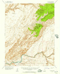
1954 Map of Clay Hills 1 NW
USGS Topo · Published 1955About this map
The high plateau of San Juan County is defined by the sharp verticality of the Stair and deeply incised drainage systems recorded during this 1954 survey. The presence of a remote Landing Strip and the Red House VABM 6725 station indicate the logistical challenges of mapping this high-elevation terrain. Water sources are critical landmarks in this landscape, with Red House Spring, Collins Spring, and Lake Buckley serving as vital points of interest for livestock and early travel routes. The map illustrates a transition from the level reaches of Pollys Pasture into the complex erosion of the Gulch. This preliminary edition captures the area before modern infrastructure arrived, showing only the most essential unimproved roads and survey monuments like Steer VABM 6701.
Find a feature on this map
11 named features on this map. Tap any name to fly to it.
Don’t see what you’re looking for? This feature index may not catch every label — zoom into the map to look around manually.
Map Details
Editions of this 1954 Clay Hills 1 NW Map
This is the sole edition of this map. No revisions or reprints were ever made.
Other maps of this area

1886 · Henry Mountains
USGS Topo · 1:250,000

1892 · Henry Mountains
USGS Topo · 1:250,000

1952 · Mancos Mesa
USGS Topo · 1:62,500

1952 · Natural Bridges
USGS Topo · 1:62,500

1954 · White Canyon 3 SE
USGS Topo · 1:24,000

1954 · White Canyon 4 SE
USGS Topo · 1:24,000

1954 · White Canyon 4 SW
USGS Topo · 1:24,000

1954 · Clay Hills 2 NE
USGS Topo · 1:24,000

1954 · Clay Hills 2 SE
USGS Topo · 1:24,000
1954 · Clay Hills
USGS Topo · 1:62,500