
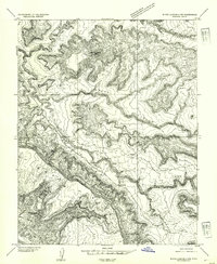
1954 Map of White Canyon 4 SW
USGS Topo · Published 1954About this map
Moss Back and the intricate drainage basins of Red Canyon dominate this 1950s topographic study of the Utah canyonlands. Mapped just after the post-war uranium boom began in the region, the landscape reveals a transition from a remote wilderness to a site of early industrial and transit infrastructure. Evidence of this shift is visible in the isolated Landing Strip near the head of Fry Canyon and the presence of a Tank in the canyon depths, likely serving early prospecting or ranching needs. The topography is defined by the sheer vertical relief of the sandstone benches, with water sources like Fry Spring providing rare relief in an otherwise arid environment. This preliminary edition captures the territory as it was being systematically surveyed for the first time by the Department of the Interior using modern aerial photography methods.
Find a feature on this map
7 named features on this map. Tap any name to fly to it.
Don’t see what you’re looking for? This feature index may not catch every label — zoom into the map to look around manually.
Map Details
Editions of this 1954 White Canyon 4 SW Map
This is the sole edition of this map. No revisions or reprints were ever made.
Other maps of this area

1886 · Henry Mountains
USGS Topo · 1:250,000

1892 · Henry Mountains
USGS Topo · 1:250,000

1952 · Mancos Mesa
USGS Topo · 1:62,500

1952 · Natural Bridges
USGS Topo · 1:62,500

1954 · White Canyon 3 SE
USGS Topo · 1:24,000

1954 · White Canyon 4 NE
USGS Topo · 1:24,000

1954 · White Canyon 4 SE
USGS Topo · 1:24,000

1954 · White Canyon 3 NE
USGS Topo · 1:24,000
1954 · White Canyon 4 NW
USGS Topo · 1:24,000

1954 · Clay Hills 2 NE
USGS Topo · 1:24,000