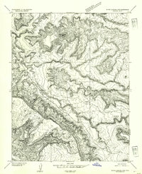
1954 Map of White Canyon 4 NW
USGS Topo · Published 1954About this map
Jacobs Chair stands as a prominent landmark amidst the intricate drainage networks of San Juan County in the early 1950s. This preliminary survey, based on 1951 aerial photography, details the rugged erosional landscape where White Canyon meets several significant tributaries, including Gravel Canyon and Fry Canyon. The map records essential points of passage across this difficult terrain, notably Soldier Crossing and Gravel Crossing, which were critical for local travel before the development of modern infrastructure. Evidence of early resource exploration is found at a specific Prospect located near the northern reaches of the canyon system. Small-scale water management is also visible through the presence of a Reservoir and the naturally occurring Rock Spring, highlighting the fundamental importance of water sources for those navigating the arid uplands of Moss Back and the surrounding mesas.
Find a feature on this map
11 named features on this map. Tap any name to fly to it.
Don’t see what you’re looking for? This feature index may not catch every label — zoom into the map to look around manually.
Map Details
Editions of this 1954 White Canyon 4 NW Map
This is the sole edition of this map. No revisions or reprints were ever made.
Other maps of this area

1886 · Henry Mountains
USGS Topo · 1:250,000

1892 · Henry Mountains
USGS Topo · 1:250,000

1952 · Mouth of Dark Canyon
USGS Topo · 1:62,500

1952 · Mancos Mesa
USGS Topo · 1:62,500

1952 · Natural Bridges
USGS Topo · 1:62,500

1952 · Hite
USGS Topo · 1:62,500

1954 · White Canyon 3 SE
USGS Topo · 1:24,000

1954 · White Canyon 4 NE
USGS Topo · 1:24,000

1954 · White Canyon 4 SE
USGS Topo · 1:24,000
1954 · White Canyon 1 SE
USGS Topo · 1:24,000