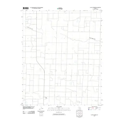
2010 Map of Clays Corner
USGS Topo · Published 2010About this map
Clays Corner sits at the southern edge of this West Texas landscape, defined by an orderly grid of county roads and the winding path of Running Water Draw. This ephemeral drainage channel cuts across the northern half of the territory, contrasting with the precise geometry of the agricultural landscape. The map illustrates a highly organized rural infrastructure, where routes such as Co Rd 17 and Co Rd 24 intersect with Fm 145 to connect local farmsteads. Land use is dominated by large-scale farming blocks, visible through the regular spacing of road intersections and the irrigation patterns typical of the Llano Estacado. Small depressions and playa lakes are scattered throughout the quadrangle, indicating the natural hydrology that persists alongside intensive cultivation.
Find a feature on this map
19 named features on this map. Tap any name to fly to it.
Don’t see what you’re looking for? This feature index may not catch every label — zoom into the map to look around manually.
Map Details
Editions of this 2010 Clays Corner Map
This is the sole edition of this map. No revisions or reprints were ever made.
Other maps of this area

1954 · Clovis
USGS Topo · 1:250,000

1958 · Clovis
USGS Topo · 1:250,000

1963 · Clays Corner
USGS Topo · 1:24,000

1963 · Lazbuddie
USGS Topo · 1:24,000

1963 · Lariat NE
USGS Topo · 1:24,000

1963 · Lazbuddie SW
USGS Topo · 1:24,000

1963 · Progress
USGS Topo · 1:24,000
1963 · Lazbuddie SE
USGS Topo · 1:24,000

1965 · Tam Anne
USGS Topo · 1:24,000

1965 · Parmerton
USGS Topo · 1:24,000