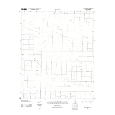
2012 Map of Clays Corner
USGS Topo · Published 2012About this map
Clays Corner serves as the primary focal point of this rural High Plains landscape in Parmer County. The settlement is situated at the junction of Fm-145 and several regional county roads, illustrating the grid-based development typical of this agricultural region. The landscape is defined by an extensive network of thoroughfares, including Co Road R at the northern boundary and Co Road Y to the south, which facilitate movement through the wide-open terrain. Scattered intermittent water features and depressions across the sheet suggest the presence of playa lakes, which are vital ecological components of the Texas Panhandle. The geometric precision of roads like Co Rd-17 and Co Rd-19 highlights the organized land division that governs the local farm and ranching economy in the early 21st century.
Find a feature on this map
18 named features on this map. Tap any name to fly to it.
Don’t see what you’re looking for? This feature index may not catch every label — zoom into the map to look around manually.
Map Details
Editions of this 2012 Clays Corner Map
This is the sole edition of this map. No revisions or reprints were ever made.
Other maps of this area

1954 · Clovis
USGS Topo · 1:250,000

1958 · Clovis
USGS Topo · 1:250,000

1963 · Clays Corner
USGS Topo · 1:24,000

1963 · Lazbuddie
USGS Topo · 1:24,000

1963 · Lariat NE
USGS Topo · 1:24,000

1963 · Lazbuddie SW
USGS Topo · 1:24,000

1963 · Progress
USGS Topo · 1:24,000
1963 · Lazbuddie SE
USGS Topo · 1:24,000

1965 · Tam Anne
USGS Topo · 1:24,000

1965 · Parmerton
USGS Topo · 1:24,000