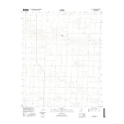
2016 Map of Clays Corner
USGS Topo · Published 2016About this map
The agricultural crossroads of Clays Corner defines this landscape in Parmer County, where a rigid grid of rural roads meets the subtle topography of the Texas Panhandle. The most prominent natural feature is Running Water Draw, an ephemeral drainage that winds through the northern half of the quadrangle, cutting across several sections of farmland. This drainage pattern provides a clear contrast to the geometric precision of the county road system, which follows the cardinal directions. Significant transport routes like Fm 145 and Co Rd 19 connect the scattered farmsteads and center at the corner itself. The terrain is characterized by numerous small depressions and playas, typical of this region, which dot the landscape alongside the extensive network of local thoroughfares such as Co Rd 17 and Co Rd 24.
Find a feature on this map
19 named features on this map. Tap any name to fly to it.
Don’t see what you’re looking for? This feature index may not catch every label — zoom into the map to look around manually.
Map Details
Editions of this 2016 Clays Corner Map
This is the sole edition of this map. No revisions or reprints were ever made.
Other maps of this area

1954 · Clovis
USGS Topo · 1:250,000

1958 · Clovis
USGS Topo · 1:250,000

1963 · Clays Corner
USGS Topo · 1:24,000

1963 · Lazbuddie
USGS Topo · 1:24,000

1963 · Lariat NE
USGS Topo · 1:24,000

1963 · Lazbuddie SW
USGS Topo · 1:24,000

1963 · Progress
USGS Topo · 1:24,000
1963 · Lazbuddie SE
USGS Topo · 1:24,000

1965 · Tam Anne
USGS Topo · 1:24,000

1965 · Parmerton
USGS Topo · 1:24,000