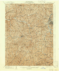
1907 Map of Claysville
USGS Topo · Published 1941About this map
Claysville stands as a central hub in this western Pennsylvania landscape, where the deeply dissected plateau of Washington County is defined by the winding courses of Buffalo Creek and Wheeling Creek. The turn-of-the-century economy is visibly split between traditional agrarian life and the encroaching industrial age, evidenced by the Arden Mine and a dense network of country schools like Sawhill Schoolhouse and Kimmins Schoolhouse. The transportation corridor is particularly well-defined, following the historic National Pike and the Baltimore and Ohio RR, which parallel one another through the heart of the region.
Find a feature on this map
86 named features on this map. Tap any name to fly to it.
Don’t see what you’re looking for? This feature index may not catch every label — zoom into the map to look around manually.
Map Details
Editions of this 1907 Claysville Map
5 editions found

Other maps of this area

1901 · Amity
USGS Topo · 1:62,500

1901 · Waynesburg
USGS Topo · 1:62,500

1902 · Wheeling
USGS Topo · 1:62,500

1904 · Amity
USGS Topo · 1:62,500

1904 · Steubenville
USGS Topo · 1:62,500

1904 · Waynesburg
USGS Topo · 1:62,500

1904 · Cameron
USGS Topo · 1:62,500

1904 · Carnegie
USGS Topo · 1:62,500

1904 · Burgettstown
USGS Topo · 1:62,500

1905 · Rogersville
USGS Topo · 1:62,500
Featured Places
- Washington, PA
- South Strabane Township, PA
- Buffalo, Hopewell Township
- Independence Township, PA
- East Finley Township, PA