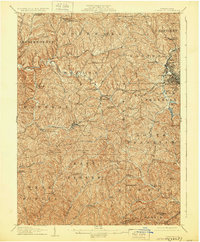
1907 Map of Claysville
USGS Topo · Published 1929About this map
The National Pike bisects this portion of Washington County, serving as a primary corridor through the rolling landscape of southwestern Pennsylvania. Near the borough of Washington, the convergence of industrial and agricultural life is evident where the Baltimore and Ohio RR and the Waynesburg and Washington RR meet. To the north, the Arden Mines signify the region's early 20th-century reliance on coal extraction, while the surrounding townships are dotted with small rural centers like Taylorstown and Claysville.
Find a feature on this map
82 named features on this map. Tap any name to fly to it.
Don’t see what you’re looking for? This feature index may not catch every label — zoom into the map to look around manually.
Map Details
Editions of this 1907 Claysville Map
5 editions found

Other maps of this area

1901 · Amity
USGS Topo · 1:62,500

1901 · Waynesburg
USGS Topo · 1:62,500

1902 · Wheeling
USGS Topo · 1:62,500

1904 · Amity
USGS Topo · 1:62,500

1904 · Steubenville
USGS Topo · 1:62,500

1904 · Waynesburg
USGS Topo · 1:62,500

1904 · Cameron
USGS Topo · 1:62,500

1904 · Carnegie
USGS Topo · 1:62,500

1904 · Burgettstown
USGS Topo · 1:62,500

1905 · Rogersville
USGS Topo · 1:62,500
Featured Places
- Washington, PA
- South Strabane Township, PA
- Buffalo, Hopewell Township
- Independence Township, PA
- East Finley Township, PA