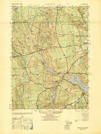
1948 Map of Clayville
USGS Topo · Published 1949About this map
Barden Reservoir and the northern reaches of the Scituate Reservoir dominate this western Rhode Island landscape, reflecting the mid-century hydrological engineering of the Providence area. The map illustrates a rural network of small settlements such as Clayville and Rockland, connected by major thoroughfares like the Danielson Pike and Plainfield Pike. Genealogists will find a high concentration of family-named landmarks and burial grounds, including the Hopkins Mills Cem and Windsor Cem, providing a clear record of local lineage and early upland settlement patterns. The terrain is characterized by a series of prominent rises like Chopmist Hill and Pray Hill, interspersed with water bodies such as Ponaganset Pond and Stone Dam Pond. This 1940s survey captures the area just as it transitioned into its modern role as a protected watershed district for the state.
Find a feature on this map
45 named features on this map. Tap any name to fly to it.
Don’t see what you’re looking for? This feature index may not catch every label — zoom into the map to look around manually.
Map Details
Editions of this 1948 Clayville Map
This is the sole edition of this map. No revisions or reprints were ever made.
Other maps of this area

1889 · Putnam
USGS Topo · 1:62,500

1889 · Burrillville
USGS Topo · 1:62,500

1889 · Moosup
USGS Topo · 1:62,500

1890 · Kent
USGS Topo · 1:62,500

1893 · Putnam
USGS Topo · 1:62,500

1893 · Moosup
USGS Topo · 1:62,500

1894 · Burrillville
USGS Topo · 1:62,500

1894 · Kent
USGS Topo · 1:62,500

1915 · Burrillville
USGS Topo · 1:62,500

1919 · Putnam
USGS Topo · 1:62,500