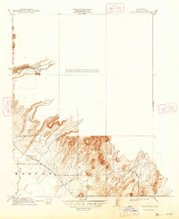
1912 Map of Clear Creek
USGS Topo · Published 1947About this map
Butte Creek carves through the northern portion of this landscape, its path traced by the historical Centerville Road during a period of transition in Butte County. Surveyed initially in 1910 and reprinted just after the second World War, the sheet documents a rugged topography defined by the Esquon region. Major thoroughfares such as the Chico and Oroville Road and Magalia Road intersect the foothills, providing a clear record of the early 20th-century transportation network connecting these regional hubs. Smaller drainage systems, including Ash Creek, Clear Creek, and Roberts Creek, illustrate the complex watershed that shaped local settlement patterns and land use before the expansion of modern infrastructure in the mid-century.
Find a feature on this map
11 named features on this map. Tap any name to fly to it.
Don’t see what you’re looking for? This feature index may not catch every label — zoom into the map to look around manually.
Map Details
Editions of this 1912 Clear Creek Map
2 editions found
Other maps of this area

1891 · Chico
USGS Topo · 1:125,000

1893 · Chico
USGS Topo · 1:125,000

1895 · Chico
USGS Topo · 1:125,000

1912 · Dry Creek
USGS Topo · 1:31,680

1912 · Durham
USGS Topo · 1:31,680

1912 · Oroville
USGS Topo · 1:31,680

1912 · Nelson
USGS Topo · 1:31,680

1912 · Keefers
USGS Topo · 1:31,680

1912 · Clear Creek
USGS Topo · 1:31,680

1942 · Oroville
USGS Topo · 1:62,500