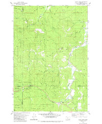
1979 Map of Clear Creek
USGS Topo · Published 1980About this map
The Nehalem River winds through this rugged timber country at the meeting point of Clatsop, Columbia, Tillamook, and Washington counties. This late-1970s landscape is defined by the logging economy and conservation efforts within the Clatsop State Forest and Tillamook State Forest. The settlement at Keasey and the small station at Clear Creek serve as quiet landmarks among a network of industrial and access routes like Mainline Road and Timber Road. Evidence of resource extraction is visible throughout the hills, including several Quarry sites and Borrow Pits near Rock Creek. The interior topography is a dense web of drainages, from the North Fork Clear Creek to the headwaters of Wolf Creek, while a small Cem and the Timber Substation mark the human presence along the river valley.
Find a feature on this map
40 named features on this map. Tap any name to fly to it.
Don’t see what you’re looking for? This feature index may not catch every label — zoom into the map to look around manually.
Map Details
Editions of this 1979 Clear Creek Map
This is the sole edition of this map. No revisions or reprints were ever made.
Other maps of this area

1940 · Vernonia
USGS Topo · 1:62,500

1941 · Keasey
USGS Topo · 1:62,500

1941 · Timber
USGS Topo · 1:62,500

1941 · Gales Creek
USGS Topo · 1:62,500

1943 · Vernonia
USGS Topo · 1:62,500

1943 · Keasey
USGS Topo · 1:62,500

1948 · Vancouver
USGS Topo · 1:250,000

1950 · Vancouver
USGS Topo · 1:250,000

1950 · Vancouver
USGS Topo · 1:250,000

1955 · Timber
USGS Topo · 1:62,500