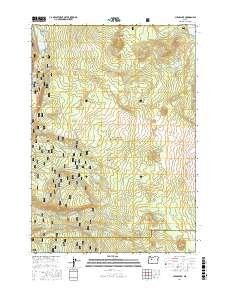
2017 Map of Clear Lake
USGS Topo · Published 2017About this map
Clear Lake dominates the northwest corner of this high-altitude landscape within the Willamette National Forest, revealing a unique volcanic history where a submerged Underwater Forest stands beneath the water's surface. Located along the border of Linn and Lane counties, the map documents the volcanic origins of the Cascade Range, featuring the distinct Twin Craters and the prominent Deer Butte. Water is a defining element of this terrain, from the dramatic Sahalie Falls and Koosah Spring on the McKenzie River to the higher elevation Patjens Lakes and Hand Lake. A network of Forest Service roads and trails, including the McKenzie River NRT and Patjens Lake Loop, provides access through the timbered ridges of Bunchgrass Ridge and the secluded Hidden Valley.
Find a feature on this map
43 named features on this map. Tap any name to fly to it.
Don’t see what you’re looking for? This feature index may not catch every label — zoom into the map to look around manually.
Map Details
Editions of this 2017 Clear Lake Map
This is the sole edition of this map. No revisions or reprints were ever made.
Other maps of this area

1929 · Three Sisters
USGS Topo · 1:125,000

1932 · Three Sisters
USGS Topo · 1:125,000

1934 · Mc Kenzie Bridge
USGS Topo · 1:96,000

1940 · Mc Kenzie Bridge
USGS Topo · 1:125,000

1953 · Salem
USGS Topo · 1:250,000

1954 · Salem
USGS Topo · 1:250,000

1955 · Echo Mountain
USGS Topo · 1:62,500

1955 · Mc Kenzie Bridge
USGS Topo · 1:62,500

1955 · Bend
USGS Topo · 1:250,000

1957 · Bend
USGS Topo · 1:250,000