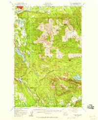
1956 Map of Clear Lake
USGS Topo · Published 1958About this map
The Skagit River meanders through the northern edge of this landscape, framing islands like Skiyou Island and Ross Island as it passes the established settlement of Sedro-Woolley. This mid-century survey captures a region defined by its timber and rail infrastructure, where the Northern Pacific railroad winds along the western valley, connecting the lakeside communities of Clear Lake, Big Lake, and McMurray.
Find a feature on this map
78 named features on this map. Tap any name to fly to it.
Don’t see what you’re looking for? This feature index may not catch every label — zoom into the map to look around manually.
Map Details
Editions of this 1956 Clear Lake Map
3 editions found
Other maps of this area

1899 · Stillaguamish
USGS Topo · 1:125,000

1901 · Stilaguamish
USGS Topo · 1:125,000

1909 · Mt Baker
USGS Topo · 1:192,000

1911 · Mount Vernon
USGS Topo · 1:125,000

1915 · Mt. Baker
USGS Topo · 1:250,000

1918 · Samish Lake
USGS Topo · 1:62,500

1921 · Wickersham
USGS Topo · 1:62,500

1940 · Mt Vernon
USGS Topo · 1:62,500

1941 · Marysville
USGS Topo · 1:62,500

1943 · Marysville
USGS Topo · 1:62,500