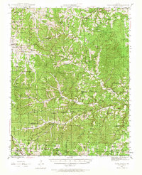
1945 Map of Clear Springs
USGS Topo · Published 1966About this map
The Ozark Plateau terrain of Texas and Howell counties is captured here in mid-century detail, centered on the headwaters of the Jacks Fork river. This 1945 survey documents a rural landscape defined by an exceptionally dense network of country schools and churches, reflecting the isolated but active community life of the era. Small settlements like Solo, Tyrone, and Clear Springs serve as local hubs, while the southern portion of the map is dominated by the Mark Twain National Forest and the broad Hutton Valley.
Find a feature on this map
64 named features on this map. Tap any name to fly to it.
Don’t see what you’re looking for? This feature index may not catch every label — zoom into the map to look around manually.
Map Details
Editions of this 1945 Clear Springs Map
2 editions found
Other maps of this area

1932 · Cedar Grove
USGS Topo · 1:48,000

1939 · Topaz
USGS Topo · 1:62,500

1941 · Topaz
USGS Topo · 1:62,500

1941 · Bado
USGS Topo · 1:62,500

1943 · Bado
USGS Topo · 1:62,500

1945 · Harrison
USGS Topo · 1:250,000

1945 · Willow Springs
USGS Topo · 1:62,500

1945 · Montier
USGS Topo · 1:62,500

1945 · Clear Springs
USGS Topo · 1:62,500

1946 · Summersville
USGS Topo · 1:62,500