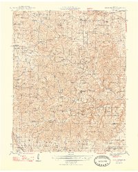
1948 Map of Clear Springs
USGS Topo · Published 1948About this map
The Ozark plateau of southern Missouri is defined here by a dense network of upland schoolhouses and rural churches serving dispersed farming communities. Small settlements like Solo, Tyrone, and Grogan anchor the landscape, while the convergence of the North Prong Jacks Fork and South Prong Jacks Fork creates a complex drainage system through Sargent and Hutton Valley. Genealogical interest is found in the numerous named schools, including French Sch, New Liberty Sch, and King Mtn Sch, which illustrate the community-centric organization of the era before major district consolidation. Religious life is equally visible through landmarks like Steely Chapel, Moores Chapel, and Bethany Ch. In the southwest corner, the St Louis and San Francisco RR provides a critical transportation link, passing near the Frisco Res and into the Willow Springs area, marking the boundary where rail infrastructure met the deep hollows of the hills.
Find a feature on this map
87 named features on this map. Tap any name to fly to it.
Don’t see what you’re looking for? This feature index may not catch every label — zoom into the map to look around manually.
Map Details
Editions of this 1948 Clear Springs Map
2 editions found

Other maps of this area

1932 · Cedar Grove
USGS Topo · 1:48,000

1939 · Topaz
USGS Topo · 1:62,500

1941 · Topaz
USGS Topo · 1:62,500

1941 · Bado
USGS Topo · 1:62,500

1943 · Bado
USGS Topo · 1:62,500

1945 · Harrison
USGS Topo · 1:250,000

1945 · Willow Springs
USGS Topo · 1:62,500

1945 · Montier
USGS Topo · 1:62,500

1945 · Clear Springs
USGS Topo · 1:62,500

1946 · Summersville
USGS Topo · 1:62,500