
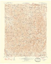
1948 Map of Clear Springs
USGS Topo · Published 1948About this map
The Ozark Plateau of south-central Missouri appears here as a landscape defined by deep-cut hollows and a dense network of country schools and churches. This 1945 survey, published just after the war, captures the rural texture of Texas and Howell Counties before modern consolidation. Numerous community centers like Tyrone, Grogan, and Clear Springs are documented alongside specialized local landmarks such as Rocky Mountain Ranch and Union Chapel.
Find a feature on this map
100 named features on this map. Tap any name to fly to it.
Don’t see what you’re looking for? This feature index may not catch every label — zoom into the map to look around manually.
Map Details
Editions of this 1948 Clear Springs Map
2 editions found
Other maps of this area

1932 · Cedar Grove
USGS Topo · 1:48,000

1939 · Topaz
USGS Topo · 1:62,500

1941 · Topaz
USGS Topo · 1:62,500

1941 · Bado
USGS Topo · 1:62,500

1943 · Bado
USGS Topo · 1:62,500

1945 · Harrison
USGS Topo · 1:250,000

1945 · Willow Springs
USGS Topo · 1:62,500

1945 · Montier
USGS Topo · 1:62,500

1945 · Clear Springs
USGS Topo · 1:62,500

1946 · Summersville
USGS Topo · 1:62,500