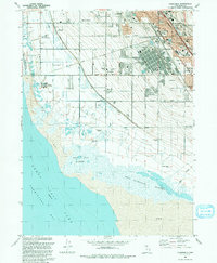
1991 Map of Clearfield
USGS Topo · Published 1991About this map
The eastern shore of the Great Salt Lake defines this landscape, where the transition from mudflats and marshes to high-intensity industrial and military development is remarkably abrupt. Hill Air Force Base and the massive industrial complex of Freeport Center dominate the northeast, signifying the area's mid-century economic transformation. Between these hubs and the water, the grid of Syracuse, West Point, and Clearfield reveals a community shaped by massive water-management infrastructure, including the Hooper Aqueduct, Layton Canal, and Davis-Weber Canal. Toward the shoreline, the West Layton Marshes and West Kaysville Marshes provide a stark contrast to the rail-heavy corridors of the Union Pacific and Denver and Rio Grande Western railroads. Local history is anchored by sites like the West Point Cemetery and several neighborhood schools, reflecting the steady growth of Davis County before the turn of the millennium.
Find a feature on this map
43 named features on this map. Tap any name to fly to it.
Don’t see what you’re looking for? This feature index may not catch every label — zoom into the map to look around manually.
Map Details
Editions of this 1991 Clearfield Map
2 editions found
Other maps of this area

1885 · Salt Lake
USGS Topo · 1:250,000

1885 · Tooele Valley
USGS Topo · 1:250,000

1925 · Ft. Douglas
USGS Topo · 1:125,000

1928 · Ft. Douglas
USGS Topo · 1:125,000

1952 · Saltair NE
USGS Topo · 1:24,000

1952 · Farmington
USGS Topo · 1:24,000

1953 · Tooele
USGS Topo · 1:250,000

1954 · Antelope Island
USGS Topo · 1:24,000

1954 · Antelope Island North
USGS Topo · 1:24,000

1954 · Salt Lake City
USGS Topo · 1:250,000