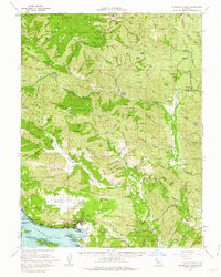
1960 Map of Clearlake Oaks
USGS Topo · Published 1962About this map
Clear Lake dominates the southwestern corner of this survey, defining the shoreline where Clearlake Oaks and Glenhaven served as established communities at the start of the 1960s. The map highlights the area's geological and indigenous history, notably at Sulphur Bank Rancheria and the nearby Sulphur Bank Mine. Moving inland, the landscape rises into the ridges of the Mendocino National Forest, where isolated outposts like Bartlett Springs and Hough Springs indicate the region's historic draw for their mineral waters.
Find a feature on this map
75 named features on this map. Tap any name to fly to it.
Don’t see what you’re looking for? This feature index may not catch every label — zoom into the map to look around manually.
Map Details
Editions of this 1960 Clearlake Oaks Map
2 editions found
Other maps of this area

1920 · Venado
USGS Topo · 1:62,500

1921 · Kelseyville
USGS Topo · 1:62,500

1922 · Hullville
USGS Topo · 1:62,500

1924 · Bartlett Springs
USGS Topo · 1:62,500

1938 · Lakeport
USGS Topo · 1:62,500

1942 · Bartlett Springs
USGS Topo · 1:62,500

1943 · Morgan Valley
USGS Topo · 1:62,500

1943 · Lodoga
USGS Topo · 1:62,500

1943 · Kelseyville
USGS Topo · 1:62,500

1944 · Bartlett Springs
USGS Topo · 1:62,500