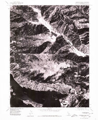
1977 Map of Clearlake Oaks
USGS Topo · Published 1980About this map
The shoreline of Clear Lake anchors this 1977 orthophotoquad, revealing the late-seventies landscape of Lake County. Visible development centers on Clearlake Oaks, where a distinctive pattern of canal-front housing extends into the water, and Glenhaven to the west. This aerial imagery provides a direct look at the mid-century expansion of lakeside communities before more modern infill occurred. Inland, the terrain transitions sharply from the developed water edge to the agricultural and open spaces of Long Valley. The map also details the natural profile of Stubbs Island, offering researchers a clear view of the topographical relationship between the lake and the surrounding ridges during this era of California's rural growth.
Find a feature on this map
5 named features on this map. Tap any name to fly to it.
Don’t see what you’re looking for? This feature index may not catch every label — zoom into the map to look around manually.
Map Details
Editions of this 1977 Clearlake Oaks Map
This is the sole edition of this map. No revisions or reprints were ever made.
Other maps of this area

1921 · Kelseyville
USGS Topo · 1:62,500

1924 · Bartlett Springs
USGS Topo · 1:62,500

1938 · Lakeport
USGS Topo · 1:62,500

1942 · Bartlett Springs
USGS Topo · 1:62,500

1943 · Kelseyville
USGS Topo · 1:62,500

1944 · Bartlett Springs
USGS Topo · 1:62,500

1945 · Lower Lake
USGS Topo · 1:62,500

1947 · Santa Rosa
USGS Topo · 1:250,000

1949 · Santa Rosa
USGS Topo · 1:250,000

1951 · Lakeport
USGS Topo · 1:62,500