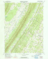
1967 Map of Clearville
USGS Topo · Published 1990About this map
Tussey Mountain and Warrior Ridge dominate this rugged section of Bedford County, creating a series of narrow, parallel valleys defined by the Ridge and Valley Appalachians. This 1967 survey, photo-revised in 1973, reveals a landscape of small agricultural settlements and rural congregations. The village of Clearville serves as a local hub near the Mann Monroe Sch and Union Ch, while smaller clusters like Ott Town and Diehl are scattered throughout the valleys.
Find a feature on this map
50 named features on this map. Tap any name to fly to it.
Don’t see what you’re looking for? This feature index may not catch every label — zoom into the map to look around manually.
Map Details
Editions of this 1967 Clearville Map
4 editions found
Other maps of this area

1900 · Everett
USGS Topo · 1:62,500

1902 · Everett
USGS Topo · 1:62,500

1908 · Bedford
USGS Topo · 1:62,500

1910 · Bedford
USGS Topo · 1:62,500

1927 · Clearville
USGS Topo · 1:48,000

1927 · Hyndman
USGS Topo · 1:62,500

1931 · Clearville
USGS Topo · 1:62,500

1931 · Hyndman
USGS Topo · 1:62,500

1944 · Hyndman
USGS Topo · 1:62,500

1944 · Clearville
USGS Topo · 1:62,500
Featured Places
- Colerain Township, PA
- Bedford Township, PA
- West Providence Township, PA
- Snake Spring Township, PA
- Koontzville, Colerain Township