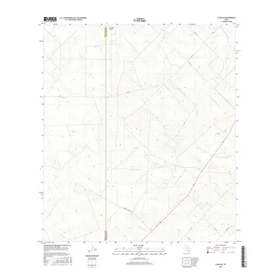
2016 Map of Clegg NE
USGS Topo · Published 2016About this map
Live Oak Hollow sits at the northern edge of this South Texas landscape, marking a terrain defined by intermittent drainages and ranching water infrastructure. The survey area follows the boundary between McMullen Co and Live Oak Co, where a network of cattle tanks including Marcou Tank, Caliche Tank, and Palo Blanco Tank provide critical water sources in an otherwise arid environment. The drainage system is dominated by the seasonal flows of Salt Br Ramirena Cr and Ramirena Cr, which carve shallow paths through the brush country alongside several smaller tributaries like Leopard Br and Tepecate Cr. Development is sparse, consisting primarily of rural routes such as Dougherty Ranch Rd and various county roads that connect isolated ranching operations. The mapping of these specific water tanks and ranch roads offers an essential look at the modern land use patterns that have sustained this region's livestock economy.
Find a feature on this map
22 named features on this map. Tap any name to fly to it.
Don’t see what you’re looking for? This feature index may not catch every label — zoom into the map to look around manually.
Map Details
Editions of this 2016 Clegg NE Map
This is the sole edition of this map. No revisions or reprints were ever made.
Other maps of this area

1920 · Mikeska
USGS Topo · 1:125,000

1927 · Oakville
USGS Topo · 1:62,500

1929 · Simmons
USGS Topo · 1:62,500

1953 · Crystal City
USGS Topo · 1:250,000

1955 · Crystal City
USGS Topo · 1:250,000

1961 · Crystal City
USGS Topo · 1:250,000
1963 · Anna Rose
USGS Topo · 1:24,000
1963 · Elm Creek
USGS Topo · 1:24,000
1963 · Oakville SW
USGS Topo · 1:24,000

1968 · Crystal City
USGS Topo · 1:250,000